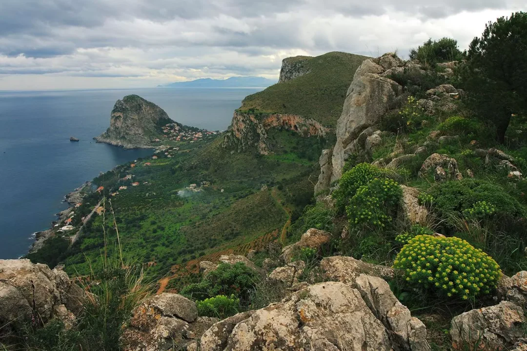
Monte Catalfano Park
The green lung of Bagheria, a corner of true nature that extends for about 274 hectares and which overlooks the inhabited area, includes, from west to east, Monte D’Aspra (Cozzo San Pietro), Monte Catalfano and Monte Città (seat of the ancient city of Solunto). The park has numerous entrances and can be visited and open to the public throughout the year with numerous paths and trails as well as a free equipped area. The walking difficulty is medium/low and is suitable for all people with a minimum of physical-sport training; it can also be reached by car up to the halfway point. The numerous paths make the area particularly suggestive and landscaped: especially at the top, spectacular views will accompany the wonderful play of colors among the green of the trees.

The Trails
1) Trail of the orchids: starting and finishing point, Mongerbino; length of the route: about 4 km; journey time, about 3 hours. The excursion starts immediately after Capo Mongerbino and continues, accompanied by the strong scents of the local flora, reaching the natural amphitheater of Vignazza, a semicircle of rock formed by numerous caves and rich in rare species of orchids. Continuing to climb, the route climbs with breathtaking views of Capo Zafferano and the coast and finally, through bends and curves, it descends until it returns to the plateau of Portella Vignazza, from which it returns to the starting point.

2) Path of the caves and zubbi: point of departure and arrival, Mongerbino; length of the route: about 4.5 km, walking time about 3.5 hours. The departure of this itinerary is the same as the previous one up to under Portella Vignazza. From here, however, you descend surrounded by lemon and olive trees and through a small hidden path you reach the “Grotta dell’Eremita”: from whose rock wall you can see a prehistoric drawing. Going back towards the Vignazza and then continuing along a path that reaches its rocky walls, one finds the entrance to the “Pilgrim’s cave”: a cave of marine origin. Resuming the path, continue slightly uphill and after half an hour you arrive at the “enclosed mouths of the Zubbio” of Cozzo San Pietro, the most interesting cave of tectonic origin from a karst point of view, with column formation due to the ramification of stalactites. About a quarter of a mile from here you can reach the crossroads that signals the “Zubbio east of Cozzo Tondo”. At a distance that can be covered in about thirty minutes, then, walking along a path that descends through hairpin bends, the large opening of the “Zubbio NW of C. San Pietro” appears, the deepest of all, wide open towards the sea.
3) Ascent to Monte Catalfano: starting and finishing point, Kafara Hotel parking area; route length 3.5 km; walking time about 3 hours. From the Hotel, as you gain altitude, a wide panorama will open up that reaches the Rocca di Cefalù. After a good uphill stretch, the path becomes less steep and turns towards the Gulf of Palermo. Continuing we will meet at a crossroads a sign indicating our direction, that is the “Trigonometric Point” which coincides with the top of the mountain.
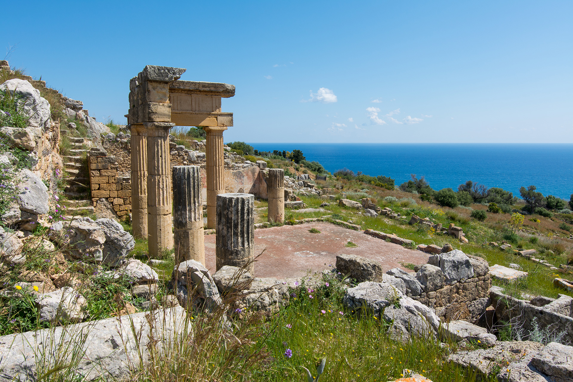
4) The “Cittadella di Solunto”: starting and finishing point, Antiquarium; length of the route, about 1 km; walking time, about 2 hours. Our itinerary starts from the entrance to the archaeological area of Solunto, and allows you to fully experience the charm of the ancient Hellenistic-Roman city. A journey through space and time that takes us almost 2500 years ago. The route introduces the urban layout of the city (so-called hippodameo) with its network of streets crossing at right angles to form regular blocks (insulae).
We immediately enter the atmosphere of the city along the main road axis (plateiaia) oriented NE-SW also known as “via dell’Agorà”, encountering the most significant places of the archaeological area such as the building called gimnasium, the so-called house “of Leda” so named for the subject depicted on the walls of one of its rooms, the sacred area with the famous altar with three betyls.
In depth
The limestone rocks of Monte Catalfano as well as a millenary natural history can tell us the story of a centuries-old human civilization. On its slopes overlooking the sea, the settlement of Solunto developed in the Punic age, a city praised over the centuries by numerous Greek and Roman authors. The first historical news relating to the presence of man in this area comes from Thucydides who, in the eighth century BC. C. at the time of the first Greek expansion, informs us of the existence (together with that of Mozia and Palermo) of the city of Solunto. The current Hellenistic-Roman vestiges present on Monte Catalfano are the remains of the city as it must have been from the mid-4th century BC. C. It was built from scratch after Dionysius I of Syracuse destroyed all the Phoenician and Elime cities of western Sicily as Diodorus tells us. The city is arranged in terraces on a plateau with a difference in height of about 50 m on the hill overlooking the sea called precisely Monte La Città, one of the hills that make up the south-eastern part of what is more generically defined as Monte Catalfano. Adolfo Holm, one of the most authoritative historians of ancient Sicily, perhaps fascinated by the wealth of buildings and the clear urban layout that the city offers, liked to define the city of Solunto as “Pompeii in small”.
The latest news on this part of the Bagheria area comes from Paolo Diacono, one of the major historians of the Middle Ages who informs us of the Soluntini massacre, of the looting and devastation carried out by the Arabs who in 831 AD. C., after a long siege, they occupied Palermo. Off Cape Zafferano then, the Byzantine ships ran to the aid of the city and were rejected by the Arabs and were destroyed by a storm. With the disappearance of the Soluntina civilization, following a progressive economic deterioration, the territory was progressively abandoned until it became a thick forest, known in the Middle Ages as “floresta dicta Bacharia” exploited by man only for the collection of wood.
The landscape and the caves
The stretch of rocky coast which, like a jagged limestone lace, extends between Capo Mongerbino and Capo Zafferano presents a remarkable morphological variety with some stretches of notable interest and suggestion. Among them there is certainly the well-known Arco Azzurro of Capo Mongerbino. Perhaps the collapse of a sea cave, of which only a splendid rock arch has been preserved to defy the force of gravity, has made this place a corner of particular natural beauty. In the 1960s, a famous chocolate manufacturing company wanted to make it “the” romantic place par excellence by arranging two lovers kissing tenderly on it to advertise its “kisses”. Then a succession of small inlets and jagged rocks until you reach Capo Zafferano where in some coves, known locally as the “pools”, due to the presence of gravel accumulations on the seabed, the sea acquires a particular emerald blue colour. To round it all off is the spectacular rocky promontory of Capo Zafferano, a 227-metre-high cliff overlooking the sea which hides a sixteenth-century watchtower at the top, while at the foot it is embellished by a characteristic building with a lighthouse. The landscape is then dominated by the mountain complex of Monte Catalfano. On the map, in reality, only the central hill is indicated with this name, which with its 373 m. asl is also the highest peak. To the west, Cozzo San Pietro (or Monte d’Aspra) stands out with its 345 m asl and Monte la Città (235 m asl) also locally known as Monte della Cittadella as it was the seat of the ancient city of Solunto. the sea acquires a particular emerald blue colour. To round it all off is the spectacular rocky promontory of Capo Zafferano, a 227-metre-high cliff overlooking the sea which hides a sixteenth-century watchtower at the top, while at the foot it is embellished by a characteristic building with a lighthouse. The landscape is then dominated by the mountain complex of Monte Catalfano. On the map, in reality, only the central hill is indicated with this name, which with its 373 m. asl is also the highest peak. To the west, Cozzo San Pietro (or Monte d’Aspra) stands out with its 345 m asl and Monte la Città (235 m asl) also locally known as Monte della Cittadella as it was the seat of the ancient city of Solunto. the sea acquires a particular emerald blue colour. To round it all off is the spectacular rocky promontory of Capo Zafferano, a 227-metre-high cliff overlooking the sea which hides a sixteenth-century watchtower at the top, while at the foot it is embellished by a characteristic building with a lighthouse. The landscape is then dominated by the mountain complex of Monte Catalfano. On the map, in reality, only the central hill is indicated with this name, which with its 373 m. asl is also the highest peak. To the west, Cozzo San Pietro (or Monte d’Aspra) stands out with its 345 m asl and Monte la Città (235 m asl) also locally known as Monte della Cittadella as it was the seat of the ancient city of Solunto. a cliff overlooking the sea of 227 meters in height which hides a sixteenth-century Watchtower at the top while at the foot it is embellished by a characteristic building with a lighthouse. The landscape is then dominated by the mountain complex of Monte Catalfano. On the map, in reality, only the central hill is indicated with this name, which with its 373 m. asl is also the highest peak. To the west, Cozzo San Pietro (or Monte d’Aspra) stands out with its 345 m asl and Monte la Città (235 m asl) also locally known as Monte della Cittadella as it was the seat of the ancient city of Solunto. a cliff overlooking the sea of 227 meters in height which hides a sixteenth-century Watchtower at the top while at the foot it is embellished by a characteristic building with a lighthouse. The landscape is then dominated by the mountain complex of Monte Catalfano. On the map, in reality, only the central hill is indicated with this name, which with its 373 m. asl is also the highest peak. To the west, Cozzo San Pietro (or Monte d’Aspra) stands out with its 345 m asl and Monte la Città (235 m asl) also locally known as Monte della Cittadella as it was the seat of the ancient city of Solunto. The landscape is then dominated by the mountain complex of Monte Catalfano. On the map, in reality, only the central hill is indicated with this name, which with its 373 m. asl is also the highest peak. To the west, Cozzo San Pietro (or Monte d’Aspra) stands out with its 345 m asl and Monte la Città (235 m asl) also locally known as Monte della Cittadella as it was the seat of the ancient city of Solunto. The landscape is then dominated by the mountain complex of Monte Catalfano. On the map, in reality, only the central hill is indicated with this name, which with its 373 m. asl is also the highest peak. To the west, Cozzo San Pietro (or Monte d’Aspra) stands out with its 345 m asl and Monte la Città (235 m asl) also locally known as Monte della Cittadella as it was the seat of the ancient city of Solunto.
On the Mount there are also numerous caves of tectonic nature or of marine origin. The caves of tectonic genesis are known in the area as “zubbi” and generally have a vertical development which in some cases even reaches several tens of metres. They are generated thanks to considerable movements or collapses of large rock masses. Among them, the Zubbio di Cozzo San Pietro is particularly fascinating due to the richness of karst phenomena with still active elements and dripping activity.
The calcareous concretions formed over time inside it take on the aspects and shapes of much more famous caves. It is thus possible to observe so-called “organ” karst morphologies with a series of columns placed side by side to simulate the pipes of the well-known musical instrument or “wall” like the mass of stalagmites that forms a wall in the center of the cavity or even the formations ” coralline”, small stick stalagmites with hints of branching. Then there are the caves of marine origin due to the slow erosive action of the sea waves. This type of cavity can be recognized by the widespread presence inside them of small perforations in the walls due tothe action of lithophagous organisms such as sea dates. The whole coast is punctured by small cavities or caves of marine origin. Among them the Cave of Cala dell’Osta where a jawbone of a dwarf elephant was found which can be seen at the Paleontological Museum “GG Gemmellaro” in Palermo. We find caves of marine origin but also at high altitudes as evidence of past eras in which the sea level and the rocky mass of the mountain were very different from those we can observe now. The most interesting of these caves on the slopes of the mountain is certainly the Hermit’s Cave. Inside, remains of a distant animal presence have been found: ribs of Bos primigenius, a prehistoric ox that lived in the Pleistocene. The cave was probably also frequented by man in prehistoric times, as can be seen from the presence inside of a black painting depicting an anthropomorphic figure. From the comparison with the prehistoric art present in other more famous caves, the painting has been attributed to the Eneolithic age (about 5,000 years BC).
On the trail of the Peregrine Falcon and other birds of prey
Rocky environments with walls and cliffs are the ideal habitat for many birds of prey that use these environments for hunting, reproduction and nesting. The Kestrel (Falco tinnunculus) is, among them, certainly the most common and most easily observable bird of prey. Specialized in hovering, it frequents different habitats getting very close or even entering the city. It will be equally easy to observe another bird of prey, more massive, with large rounded wings (which it holds with the tip upwards in flight) as it climbs higher and higher making large concentric circles in the sky. This time it is the Buzzard (Buteo buteo), a bird of prey with reddish brown plumage that varies greatly from dark to light up to almost white. If, on the other hand, we focus our attention on the steepest and most overhanging walls of the mountain, we will notice yet another bird of prey making the “kite” and then throwing itself into a lightning dive. It is the fastest bird in the world and one of the biggest and haughtiest falcons in our country. During its hunting dives it can even reach 240 km per hour! At this very high speed, the Peregrine Falcon (Falco peregrinus) nevertheless manages to be very precise in hitting or snatching its prey in flight. He is the ruler of the cliffs of Monte Catalfano where he mainly hunts medium and small sized birds (wild and domestic pigeons, starlings, goldfinches).
Botanical rarities or the flagships of Monte Catalfano
On the most inaccessible rocks where the hand of man has rarely reached, the vegetation that best represents the original aspect of the place has been preserved. The rocky cliffs exposed to the north or north-east thus host a rock vegetation of exceptional value with numerous endemic entities or of particular phytogeographic interest. Among them the everlasting Iberian (Iberis semperflorens) which in winter and spring is filled with inflorescences full of small candid and fragrant little flowers or the Sicilian starlet (Asperula rupestris) with its erect branches which in spring are filled with small rosy flowers – violets. Among the rocks, the rock carnation (Dianthus rupicola) with its lilac-pink flowers gathered in dense bunches and the rock wallflower (Matthiola incana subsp. rupestris) with its showy flowers of an intense violet colour, the rock cabbage (Brassica rupestris subsp. rupestris) with pale yellow flowers, the rock fennel (Seseli bocconi subsp. Bocconi) with its greenish-white umbel-shaped inflorescences, the Ciombolino (Cymbalaria pubescens) with its hanging hairy stems on which the small purplish-blue flowers stand out, the spectacular Pearl grass (Lithodora rosmarinifolium) with its beautiful gentian blue flowers and the Turkish bindweed (Convolvolus cneorum) with its large candid calyxes veined with rose. The rock areas are also the realm of the rarest of the plants present on the mountain: the rock cornflower (Centaurea ucriae subsp.todari). It is an exclusive variety of Monte Catalfano and is immediately noticed for its large lilac-purple flower heads. In dry meadows, in the garrigues and in the semi-rocky habitats we find other typically North African rarities such as the Speronella (Delphinium emarginatum) which, with its tall erect inflorescence full of showy blue-violet flowers, is immediately noticeable, the Bivona Euphorbia (Euphorbia bivonae) of particular charm and beauty for its reddish branches that contrast with the glaucous green of the leaves or the Serratula (Klasea flavescens subsp. mucronata) with graceful squamous-thorny flower heads and prupureous flowers. Endemic species of Sicily and Puglia, the Sicilian iris (Iris pseudopumila) finally surprises with the “Renaissance” beauty of its fragrant lilac flowers edged in yellow. The calcareous rocks facing the sea are also the preferred habitat of the rock Perpetuin (Helichrysum rupetre var. rock) which, as the name suggests (from the Greek Elios = sun and crisos = gold) with its yellow flowers illuminates our rocky coasts. Finally, in the uncultivated fields we can find a pearl of rarity reported for Sicily only in this area, the Lathyrus saxatilis, a relict species and therefore of particular phytogeographical importance.
Botanical splendours, orchids
Despite its small size, the territory of Monte Catalfano is extraordinarily rich in wild orchids (33 species)! From winter to late spring, the orchids bloom in the scrub and garrigue environments, in the meadows and in the areas subject to reforestation, which make this place particularly precious. From the rarest to the most common, they all exert a powerful fascination and intrigue the hiker. They range from common and easy to observe species due to the size of the plant such as the Barlia or Barbone (Barlia robertiana) which, with its inflorescence made up of delicious and fragrant lilac-pink flowers tinged with green, reaches up to eighty centimeters in height, to more difficult species to identify such as the Fior di Bombo (Oprhrys bombyliflora) which with its small flowers slightly larger than 1 centimeter generally only reaches a height of 10 cm. The most widespread genus is certainly the genus Oprhrys with very rare species such as the admirable ophryd (O. mirabilis), the crescent ophryd (O. lunulata), the sharp-beaked ophryd (O. oxyrrhynchos) and the ophryd palermitana (O. explanata) endemic to our island alone. The orchis genus is also very present with rare species such as the iridescent orchid (O. commutata) Sicilian endemism or the Branciforti orchid (O. branciforti) present only in Sicily, Sardinia and in only one station in Calabria. The most fragrant of the orchids present on the mountain is certainly the Perfumed Orchid (Anacamptis coriophora subsp. fragrans) which, as the scientific name suggests, gives off a “fragrance” that tastes like vanilla. An orchid that can also be looked for “by nose” among the garrigue scrub in the month of May. The strangest and “hairiest” is instead the blue Ophrys (Ophrys speculum) which, very small, stands out for its long “eyelashes” and for the glossy blue spot on the labellum from which the common name of Venus mirror.
(source: The “Nature and Culture” tourism promotion association )